Sometimes things happen by accident that can cause a whole heap of problems and I have just heard of one. In this day and age you would think these things would have already been ironed out, but not yet on this one.
I heard about this on the Utah Wildlife Network Forum just this very day. It involves the border between Utah and Idaho, not far from where I am sitting right now.
A little history: Utah was made a state in 1896 and of course there needed to be a defined boundary of the extent of the states exterior. After all Utah could have stretched all the way to the Pacific Ocean if the political powers had wanted it to. But because of the nature of the people residing there, they wished they could contain them in as small a space as they could. And besides, there wasn’t much good land West of Salt Lake City anyway, so let the boundary be way out there in the salt desert somewhere. Let the Southern boundary be covered by the deep gorge that is naturally down that way and then because the Idaho territory had already defined its Southern edge as the 42nd parallel, let the Northern edge of Utah be that same parallel.
Yes, there are some other adjustments needing to be made, but we can work them out later on.
So, the boundary between Colorado and Utah was defined and surveyed beginning at the point where Colorado, New Mexico, Arizona and Utah all come together. The four corners…Someone piled some rocks up there and said…this is it!
Then the survey guys started to head straight North from there…oops…they got off a bit somewhere when someone during the night tripped over the survey dealie they had been working with during the day causing it to point in a slightly Westerly direction when the work resumed the next morning. Nobody was to the wise and so that border got all messed up and still is today. That is not the point of this writing. What is, is about to be divulged.
Just East of a point slightly North of the town of Portage, Utah on the East side of Interstate 15 is the point of this discussion. It was said that the 42nd parallel would be the South border of the Idaho territory at the time. That seems like a reasonable thing to be saying and for a surveyer to define and poke sticks in the ground marking such a nice straight line that extends all the way around the earth, I might add, would be an easy thing to do.
BUT….right where I just pointed to is a mistake. By whom? I can’t say but I’ll tell you about it and you decide…I like things that happen and you decide, because it takes the blame off me. I’ll tell you what I think later on.
Ok, so here are these survey guys called “Hansen”, they have been surveying for a whole lot of years and they know everything about the job they do. They have specialists that do nothing but call the shots and others who run and poke sticks in the ground and they charge a lot of money to do just that. On this particular surveying job they were high up on the mountain trying to figure out how to go in a straight line across a deep gorge and get exactly where they needed to be on the other side. It’s rocky and craggy and filled with poisonous snakes and wild critters and so they decided to cross at a point somewhat sooner than perhaps their instruments were telling them they had to cross. It was easier that way and safer too I might add. (All of this is my speculation, because the instruments they had were the best of the best at the time even for 1896, the year the survey took place). So, they poked their sticks in the ground and went on about their business and reported to the authorities their findings, collected up their cash and headed out the door.
But HOLD ON a minute here. Something does not look right. I’m standing on the 42nd parallel and it aint straight. There is a crook in it right here in front of me. And it goes to my right as I am looking due West along this 42nd parallel line. What is going on? I will need another survey company to come and check this out. So I gather up another bucket of cash and call on a guy named “Sonnenkalb”, a German survey guy who knows EVERYTHING there is to know about surveying and he and his company have the “German version” of the best of the best in surveying equipment. It has to be better than what Hansen had and he will make sure the line is good and straight and he will pick up all of Hansens sticks that were poked in the ground and everything will be a good as it can be.
So Sonnenkalb goes out and uses his vast knowledge to survey the 42nd parallel as best as it can be surveyed only it is now two years later than Hansens time at it. The year is 1898. What could have possibly changed in two years? Maybe climbing equipment, or men with more courage than two years earlier. Perhaps they were being paid more to do more daring things. Whatever the reason, Sonnenkalb and his crew made their line really straight, long past when Hansens crew decided the snakes and critters were too much to handle if they continued to go straight, and they ended up coming across Hansens sticks poked in the ground and their equipment was telling them all was well and they had marked the 42nd parallel perfectly straight and so, this new series of poked in the ground sticks is THE place that marks the exact border between Utah (the new state) and the territory of Idaho.
HOLD ON AGAIN! Ok, so I walk West along Sonnenkalbs line, I pass the place where the Hansens went to my right, but now Sonnenkalbs line is going to my right just like Hansens did. What is with this? Isn’t the 42nd parallel parallel? How can something that is parallel with something else have a jog in it? Mathematically it can’t. Logically it can’t. According to Martha Stewart it can’t. According to my gut it can’t.
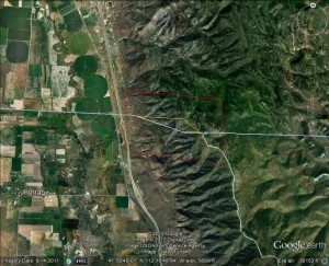
And so, the money divy-out-ers decided that two survey companies did the best they could to define the 42nd parallel and both of them have jogs in their lines, and they are not about to pay a third company to try and straighten out the 42nd parallel with sticks poked in the ground. So now the dilemma. Is the Hansen jog correct or is the Sonnenkalbs jog correct? Here is what it looks like via Google Earth…the lines are approximate according to my survey eye….I think as closely approximated as both Hansens and Sonnenkalbs….of course in my humble opinion.
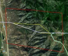
Let’s look closer at the issue:
Hansens line is the yellow one, while Sonnenkalbs is the bluer of the two.
A trapezoidal piece of ground that could put you into Utah, or it could have you paying taxes to Idaho.
I looked extensively at the internet and could not find where either state had agreed to which survey was the most accurate, however someone on the forum said that Idaho honored Sonnenkalbs and that was probably because Sonnenkalb was a company licensed in Idaho and the company president resided in one of Idahos favored cities. On the other hand Utah had the Hansens licensed and living in their fair state.
I question now, why the two surveys were not just averaged and that piece of jog agreed upon by all parties concerned, but it has not been averaged and to this day the folks at the U.S. Geological Survey office and all their Geographic Information Specialists are accepting Sonnenkalbs survey as “The La One” that is the most accurate, mostly because it was “the last one done”, with no regard to the Hansen survey…was their any dispute handling in court? Were the Hansens even brought in for questioning and given a chance to prove their survey is the more accurate? I think theirs IS more accurate than Sonnenkalbs and that means a lot to me.
So, if my judgement holds true that Hansens survey is the more accurate and Idaho people think Sonnenkalbs is more accurate, that would make this trapezoidal piece of ground located in neither Utah nor Idaho and if I wanted I could go and claim it as my own state, make myself governor and grow a cash crop on it, if I so choose…right? The Trapezoidal State of Bears Butt. No roads, No taxes, No nothing. A right to work state where everyone is required to carry a side arm and speak English.
Maybe I should check the county records of each state first to find out if someone owns it before I go put up my sticks and begin protecting my borders.
Bears Butt
Dec. 6, 2012


 Utah Fishing Reports

Leave a Reply